Drone Footage Reveals Texas Trail Of Destruction
Another round of dangerous storms tore through the Plains Sunday afternoon and evening, the latest in a multi-day siege of deadly severe weather. Below, you can find our live updates from Sunday night, and for more on the severe weather and tornado threat in the days ahead, read our forecast article.
From meteorologists Rob Shackelford and Caitlin Kaiser:
The severe storm threat is expected to continue through the overnight hours, especially for the Central Plains.
Parts of southern Kansas and northern Oklahoma have the potential to see strong tornadoes over the next hour or so.
The storm that produced the large and dangerous tornado in Sycamore, Kansas, continues its track to the east across southern Kansas and will eventually head into Missouri. While the storm has no observed tornado on the ground at this time, storms that have a history of tornadoes have the potential to generate more.
So far this evening, we have seen 41 hail reports, 16 damaging wind reports and two tornado reports across the Plains. These numbers will likely continue to rise overnight.
While we don’t yet know how severe the damage is, emergency managers are reporting that there is damage in Sycamore, Kansas, a town with a population of about 70 people in Montgomery County, Kansas. Fire and EMS are on their way to the town.
Storm chaser Charles Peek is sharing video on social media showing the tornado attempting to spin up in Sycamore, Kansas, which is under a PDS tornado warning:
A “particularly dangerous situation” tornado warning has been issued for Montgomery County, Kansas, in the southeastern portion of the state. Towns included in this PDS tornado warning include Sycamore and Cherryvale.
“You are in a life-threatening situation,” said the National Weather Service. “Flying debris may be deadly to those caught without shelter. Mobile homes will be destroyed. Considerable damage to homes, businesses, and vehicles is likely and complete destruction is possible.”
With the threat of tornadoes expected over the next several hours, we should break down the types of tornado warnings.
The first is a “radar indicated” tornado warning. This doesn’t mean that a tornado has been confirmed but it could be at any moment. Take these warnings as seriously as any other warning.
The next is tornado warnings with a confirmed tag. There are two types: radar confirmed and spotter confirmed.
Then, there are Particularly Dangerous Situation (PDS) Confirmed Tornadoes. These are rare and an elevated version of a tornado warning and suggest an unusually high threat of damage and loss of life.
Finally, there is a tornado emergency. This is the rarest type of warning and is only used for dire situations.
To find more information on the different types, click here.
From meteorologist Rob Shackelford:
A tornado watch has been issued for southern Missouri until 2 a.m. local time.
The main threats are a few tornadoes, tennis-ball-sized hail (2 inches in diameter) and wind gusts to 70 mph.
The combined population under tornado watches between the four tornado watches is now over 4 million people.
From meteorologist Caitlin Kaiser:
A hailstone 3 inches in diameter was reported in Iowa City, Texas — the largest hail report so far this evening.
The threat for 2- to 3-inch hail is increasing across parts of northern Texas and southern Oklahoma, as well as the chance of a tornado.
Another notable report was a 2-inch hailstone in Madison, Kansas. In total, there have been more than 20 hail reports so far, with the bulk of them occurring in Kansas. This number is expected to increase as the night progresses.
From meteorologist Rob Shackelford:
As storms continue to fire up across the Central Plains, here’s a brief forecast of where storms should be in the next few hours.
The main line of storms we have been watching are moving through southern Kansas into Iowa and Missouri. This line of storms has a history of severe thunderstorms and tornado warnings because it has plenty of moisture and instability, ingredients necessary for severe storm development. The strongest storms are expected on the southern end of this initial line of storms.
Storms will fill in behind this initial line and will move through the same areas in the coming hours, which could bring another round of gusty winds, large hail and even the threat of a strong tornado. This second round of storms is expected to follow in the footsteps of the first line, so along with the severe storm threat, heavy rainfall is also possible.
Southwest of Kansas City, homes were damaged and a barn was destroyed near Edgerton, Kansas, according to local storm reports. No further details were immediately available.
From meteorologist Rob Shackelford:
The tornado watches are beginning to fill in across the Central Plains as storms are ramping up across the region.
The third tornado watch of the night has been issued for parts of northeastern Oklahoma and northwestern Arkansas. This watch includes the city of Tulsa, Oklahoma.
The main threats are a couple of intense tornadoes, large apple-sized hail (3 inches in diameter) and gusts to 70 mph.
The combined population under tornado watches between the three tornado watches is now over 3.5 million people.
From meteorologist Caitlin Kaiser:
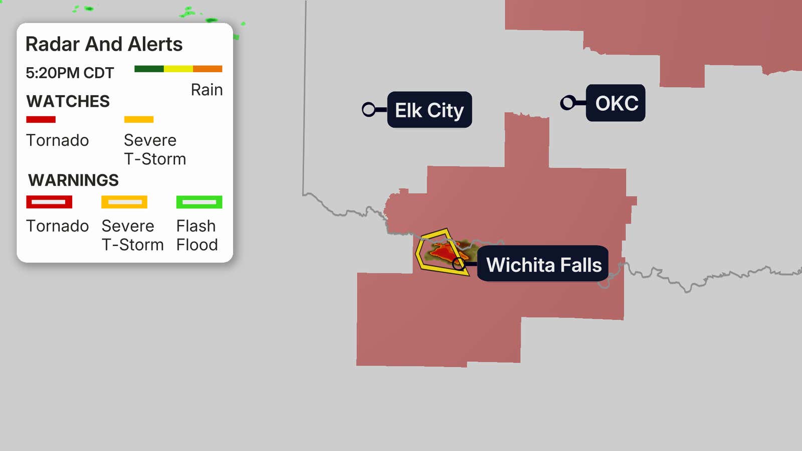
After a quiet afternoon, we are starting to see storms pop up in Texas.
The first severe thunderstorm warning for the Lone Star State has been issued for a cell moving toward Wichita Falls.
The storm could bring golf ball-sized hail and winds up to 60 mph.
The conditions are expected to continue to deteriorate across the tornado-watched area in the coming hours.
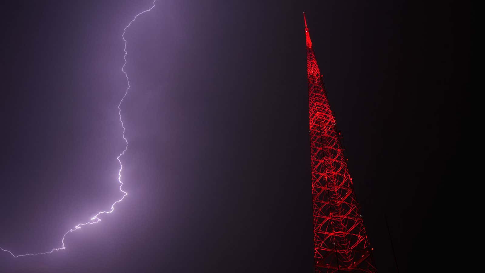
Lightning lights up the sky behind a television tower as a thunderstorm moves through the area Thursday, April 23, 2026, in Kansas City, Missouri.
(AP Photo/Charlie Riedel)
Is your area under the threat of severe weather tonight? It’s important to be prepared before the storms reach you.
Meteorologist Caitlin Kaiser breaks down the common mistakes people make and some potentially life-saving tips to help you prepare here.
From meteorologist Rob Shackelford:
A line of powerful storms is moving across eastern Kansas just south of Kansas City.
These storms have severe thunderstorm and tornado warnings issued for them, where gusts to 70 mph, ping-pong-ball-sized hail and even a tornado are possible.
These storms are also expected to have more storms build in behind them, leading to heavy rainfall “training” over the same areas. That means we could see flash flooding in these areas, as rainfall rates of 1 to 2 inches per hour are possible. There is a flood watch in effect for these areas, including Kansas City.
From digital meteorologist Caitlin Kaiser:
A tornado watch has been issued for parts of Oklahoma and Texas until 11 p.m. local time. The main threats are hail up to the size of an apple, wind gusts up to 70 mph and a couple of tornadoes.
From digital meteorologist Rob Shackelford:
The first tornado watch of the night has been issued for parts of Kansas and Missouri until 11 p.m. local time.
The main threats are tornadoes, hail up to tennis ball size and wind gusts up to 75 mph.
Here’s how you can tell the difference between a tornado watch and a tornado warning.
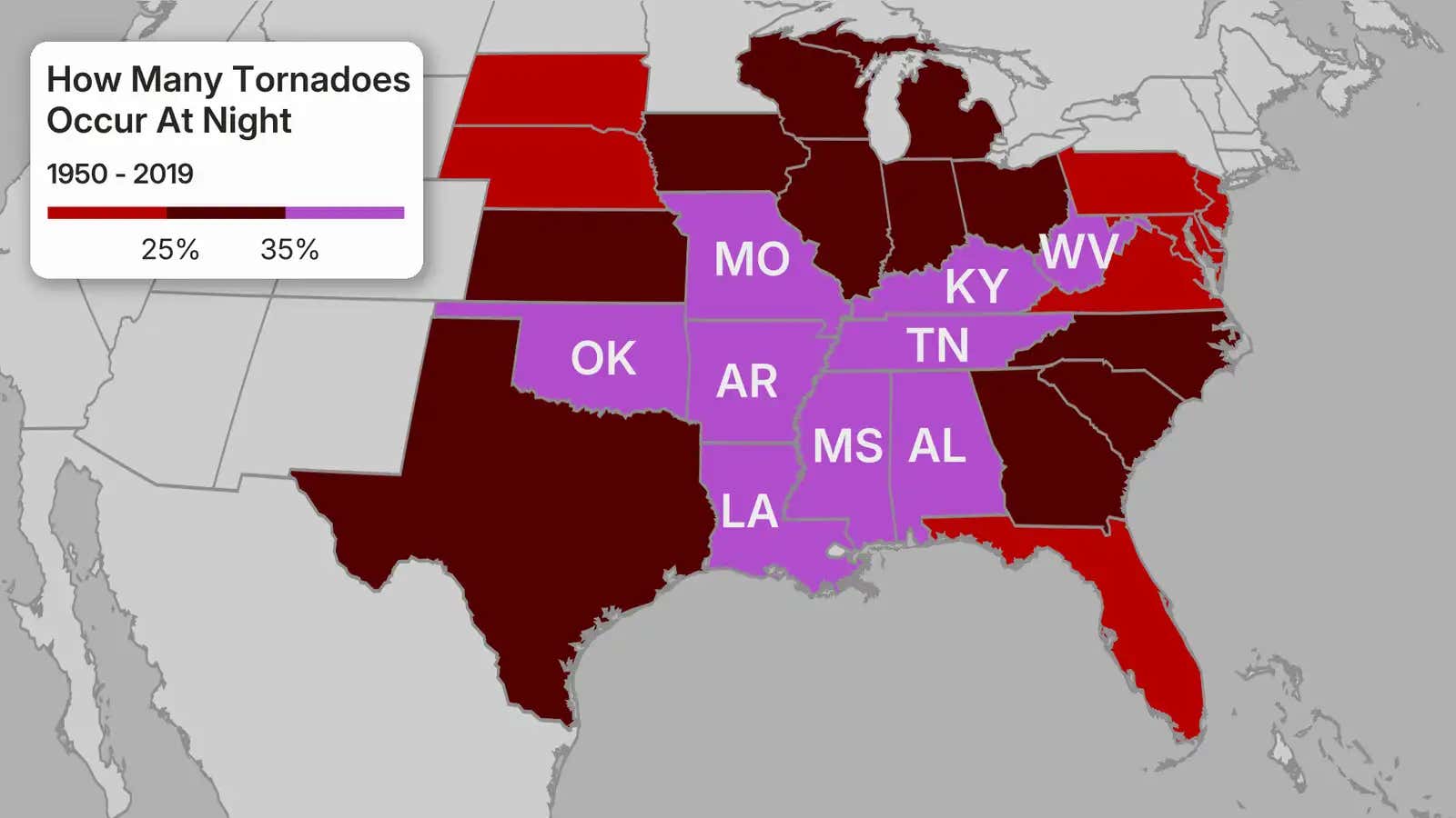
The threat of tornadoes is expected to last into the overnight hours, and a recent study has confirmed that nighttime twisters are nearly twice as deadly as daytime tornadoes.
There are several reasons for the increased risk. The most obvious one: visibility. Nighttime tornadoes are only illuminated by lightning, which lasts for a few seconds.
Also, there aren’t as many storm chasers and trained spotters out after dark.
The biggest reason for the increase in fatalities for nighttime tornadoes is that you can be asleep while the threat tracks through your area.
Meteorologist Rob Shackelford breaks it all down here.
From meteorologist Caitlin Kaiser:
Severe weather tonight could bring the threat for large to very large hail across parts of the Plains, including places like Kansas City, Wichita, Dallas and Oklahoma City.
The hail could be as large as 2 to 3 inches in diameter. But how big actually is this?
Hail that is 2 inches in diameter is comparable to a hen’s egg, while 3-inch hail is similar to a large apple.
Find more information here on hail and the type of damage it can cause to you and your property.
According to the Associated Press, two people died late Saturday night when tornadoes caused major damage to homes in multiple North Texas towns. An EF2 tornado brought 130-mph winds to Runaway Bay, killing one person. Later in the evening, an EF1 tornado with 105-mph winds killed another person on the south side of Springtown.
“Access has been difficult due to blocked roadways and downed utilities, but crews have continued pushing forward to reach those in need,” Wise County Judge J.D. Clark told reporters. “Roads in the affected area will remain closed by law enforcement to ensure safety and allow emergency crews to manage the scene without obstruction.”
From meteorologist Jennifer Gray:
A dangerous weather weekend and start to the upcoming week continues across the Plains and Midwest that has already claimed two lives. Significant threats of tornadoes, hail and damaging winds extend through Tuesday.
The threat of supercell thunderstorms is in play in the Central and Southern Plains, especially in parts of Kansas, Nebraska and Missouri.
With enough warm, humid air and strong wind shear in place, these supercells could spawn strong tornadoes, in addition to very large hail and damaging wind gusts. Cities like Kansas City and Oklahoma City need to be on alert.
A lower severe storm threat could impact cities like Dallas, San Antonio and Austin with large hail and damaging winds.


Leave a comment